

Introduction
For effective silviculture management, stand characteristics and activities need to be accurately monitored. Cost effective solutions have been developed to assess the performance of silvicultural activities. Custom data acquisitions systems such as LiDAR and GIS have been developed to collect inventory data from seeding stage to mature trees. Enhanced inventory information provided by the technologies puts the industry in a better position to allocate wood for best end use and provide more accurate costing of wood in harvest planning systems. Moreover, information derived from remote sensing provides more accurate information on tree height, volume and new variables that measure wood properties.
The importance of LiDAR, GPS and GIS systems
Live seedlings identification is important for monitoring the success of forest establishment and to ensure that the planting density and spacing dimensions are maximised. Using remotely sensed data, the automation of seedling detection could provide a more efficient, safe, and accurate survey method with additional benefits of geolocating seedlings. Furthermore, with the help of unmanned aerial vehicles (UAVs) the location of tree seedlings can be documented and activities such as fertilisation and weed control can be carried out with precision.
How does it work
The combination of GPS, GIS and LiDAR systems has great potential for use in silvicultural operations. These systems are used individually to gather inventory information that is useful and useable by forest silviculture managers. GPS helps in providing the location of seedlings planted by machines, GIS integrates the information to a form of visualisation which enables us to see where the trees are located and then LiDAR monitors the survival of the planted trees using light detection and ranging to monitor various things such as survival, mortality, quality of espacement, tree health etc.
GPS
GPS is a key technology that enables the system operator to identify and monitor the exact location of their resources. GPS systems which can be integrated to pitting and planting equipment so that the machine can capture the planted seedling location. This helps forest managers to better manage their inventory as this information is projected to them in real time. Tracking then becomes easier when the location of the seedling is known moreover, tree mortality assessment, operations such fertilization, weed control can be carried out with precision. Novelquip, Risutec, Trimble are manufactures that use these systems.
Source: Risutec
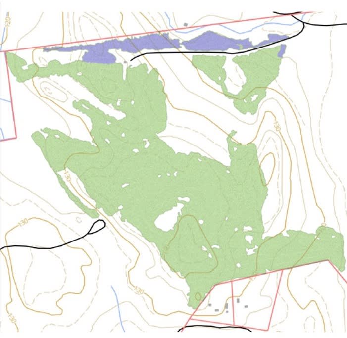
GIS
According to the National Geographic Society (2022) GIS is a computer system for capturing, storing, checking, and displaying data related to positions on Earth’s surface. With GIS technology, people can compare the locations of different things to discover how they relate to each other. GIS and related technologies provide an excellent platform for forest manager to keep records, analyse and make decisions. This then makes planning operations and management of resources easier. GIS is used to integrate information obtained by the GPS to a form of visualisation which enables forest managers to see where the trees are located by providing the name of the place, or geographic reference such as latitude and longitude. Swift Geospatial is a company that uses GIS for forest monitoring
LiDAR
LiDAR is an active remote sensing technique that measures distance with unprecedented accuracy. It is airborne optical remote-sensing technique that uses shorter wavelengths in the in the electromagnetic spectrum, typically in the ultraviolet visible or near-infrared are transmitted at frequencies up to 150 kilohertz (kHz) consists of a laser, a scanner, and a specialized GPS receiver. Airplanes, helicopters, and satellite technology are the most used platforms for acquiring LiDAR data over broad areas. This then allows mapping of the forest canopy surface, the tree structure, and the underlying topography. LiDAR’s ability to penetrate forest canopies, mapping of the topography and capturing data is of great benefit. In silviculture operations LiDAR is used to monitor survival, mortality, quality of espacement, tree health. Swift Geospatial and Skylab are some of the companies that use LiDAR systems.
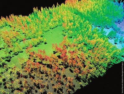
Source: Globalspace.com
Benefits when using these systems
GIS provides forest managers with information efficiency through a combination of photo interpretation and algorithms. Moreover, the use of LiDAR information obtained during the growing stages of seedling to trees guarantees quality information. LiDAR and GIS technologies are being used around the world to identify and map the growth of seedling to trees and the use of these systems improves operational efficiency and reduces the cost of wood fibre. These systems are developed with algorithms which facilitate automatic seedling counting thereby obtaining a high degree of precision in counting effective trees, differentiating weeds and other false/positives that could generate a greater number of plants than the existing ones. This information enables easier blanking operations and weeding. These systems have the potential to improve guidance for forestry site preparation operations, fertilization, blanking and weeding operations. Aerial monitoring and surveying acquires trusted and high-quality data and evaluates the effectiveness of forest and range practices in achieving management objective, including sustainable resource management. Data collected provides the foundation of evidence to enable continuous improvement in resource stewardship principles. Tree count/ survival rates, harvesting analysis, infield tree stress, species identification and heights, site species matching tool, woodlot mapping and monitoring, post fire analysis are the benefits of using satellite imagery systems through Swift Geospatial
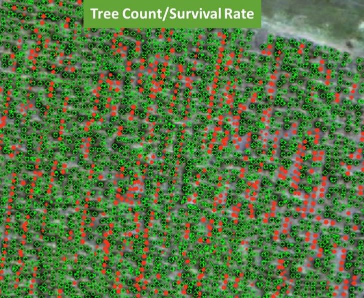
Source: Webinar presentation
Conclusion
With the rate at which technology is growing forest operations are made easier and the use of geospatial technologies which puts together GPS, GIS, remote sensing, LiDAR etc. as tools assists in site specific forest management, planning and silvicultural operations. Remote sensing and other methods on the ground will make it possible to track tree growth during the rotation as track types, prescriptions and operational practice dates are recorded. The data recorded can help managers to analyse survival rates, wood fibre growth rates and final wood quality. As the limitations of LIDAR data sets are overcome, its ability to produce unprecedented detail when calculating canopy height, tree density, volume estimates and underlying topography enable a bright future in the field of forestry management and related operational activities.


